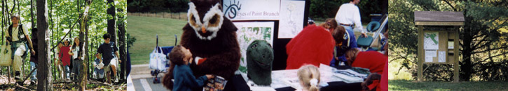
Eyes of Paint Branch
Conservation, Education, and Action for the Paint Branch and Its Watershed
Basic Watershed Information
Paint Branch Location:
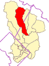
The Paint Branch Watershed (red) is a part of the Anacostia Watershed (yellow)
Maps of the Paint Branch Watershed
Learn more about the Anacostia Watershed
Paint Branch Watershed Facts:
Total Area: 13,287 acres
Avg. Imperviousness: 18%
Population: 53,659
Population Density: 2,585/mile2
Forest Cover: 26%
Deciduous: 1,808 Acres
Coniferous: 65 Acres
Mixed: 329 Acres
Shrub/Scrub: 407 Acres
Undefined: 822 Acres
Wetland Cover: 2.8%
Emergent: 7 Acres
Forested: 212 Acres
Open Water: 118 Acres
Shrub/Scrub: 34 Acres
The Paint Branch begins as a few small springs, which flow from the ridgeline south of Route 198 in Spencerville, Maryland. It becomes a single stream just above Fairland Road. Roughly half of its 17-mile length is in Montgomery County, the lower half in Prince George's County. Pant Branch begins at an elevation of approximately 480 feet and flows southeast. The stream drops to about 30 feet above sea level when it meets Indian Creek to form Northeast Branch in College Park. It collects many tributaries along the way, the principal being Little Paint Branch. Overall, it drains 31.5 square miles of land. The Paint Branch subwatershed boundary is generally outlined by Cherry Hill Road to the east, New Hampshire Avenue to the west, and Spencerville Road to the north. Seventy-two percent of the subwatershed is in Montgomery County, with the remaining 28% in Prince George's County.
Dominant Land Uses:
Dominant land uses in the Paint Branch subwatershed include residential (42%), forest cover (26%), agricultural (12%), institutional (10%), and parkland (5%).
Physical Characteristics:
The Paint Branch subwatershed is 13,287 acres (20.7 mile2) in size and approximately 18% impervious. Elevations range from just above 500 feet along the subwatershed divide to 35 feet at its confluence with Indian Creek. With an average mainstem gradient of 0.57%, Paint Branch flows from the Piedmont physiographic province into the Coastal Plain.
Biological Characteristics:
State regulators have designated the lower portion of Paint Branch (from Interstate 495, downstream to its confluence with Indian Creek), as Use I waters. The upper portions of Paint Branch (from Interstate 495, upstream to its headwaters) have been classified as Use III waters by the state. They support a naturally-reproducing population of Brown Trout and the highest quality aquatic biotic populations in the Anacostia (Cummins et al. 1991). While not nearly as pristine as its upper reaches, the downstream reaches of Paint Branch also support high quality populations of aquatic biota. Cummins et al. 1991 identified some impairment to associated macroinvertebrates ranking them at 87% of the reference site.
Condition Summary:
Paint Branch is one of the least intensely developed subwatersheds of the Anacostia. The subwatershed consists predominantly of moderate-to-low density residential development, forest cover, and remaining agricultural areas; its 26% forest cover is average among other Anacostia subwatersheds. Fifty-three percent of the stream miles of Paint Branch have an adequate riparian forest buffer (300-foot total width), which is confined almost exclusively to the upper two-thirds of the subwatershed. This forest cover helps to preserve groundwater recharge areas and maintain the seeps and springs critical to the temperature regime required by trout, as well as, helping to maintain the highest quality of streamflow found in the Anacostia Watershed, and associated aquatic habitat, and biota for which Paint Branch is renowned--upstream of I-495, the stream supports the only self-sustaining Brown Trout population in the Washington Metropolitan area. Research has indicated that this resource is being increasingly threatened by new and expanding development and may be approaching its upper threshold for trout sustainability (Galli, 1994; Gougeon, 1993). However, in a landmark decision, the Montgomery County Council recently approved the acquisition of 248 acres of Stream Valley Conservation Parkland in the two principal trout spawning areas (i.e., Good Hope and Gum Springs tributaries). An additional 130 to 140 acres are also being considered for acquisition in the Right and Left Fork tributaries.
Relatively good conditions also are observed in the lower portion of the subwatershed as compared to other Anacostia tributaries. However, both the quality of the water and the condition of the downstream fishery and associated habitat have been impaired. This impairment is due to higher levels of imperviousness associated with increased development density, associated stormwater impacts, stream channelization, loss of riparian buffering and streamside forest canopy and increased thermal loads. In a related area, MWCOG and ICPRB staff have been successful in working closely with USDA Beltsville Agricultural Research Center (BARC) land managers to curtail the practice of streamside mowing. This cost-effective change in land management has dramatically improved the stream canopy, resulting in stream shading and cooling, increased bank stability, terrestrial and riparian habitat, and coarse particulate organic material input to the stream ecosystem. Additionally, cooperative (BARC, MdDNR, and MWCOG) thermal studies of the mainstem of Paint Branch through the BARC property are ongoing to assess the effectiveness of these management changes in improving the stream's thermal regime.
Summary Reference Information
Dominant Land Uses
Summary of the largest Anacostia land use/land cover categories by area in the subwatershed; general categories include residential, commercial, industrial, institutional, agricultural, parks, forest, wetlands, extractive federal, and water.
Physical Characteristics
Subwatershed features such as size, physiographic province(s), percent impervious, elevation range, and stream gradient.
Biological Characteristics
The quality of the fish and macroinvertebrate community and the condition of the aquatic habitat. In the Maryland portion of the watershed, aquatic biota and habitat condition are presented as scores relative to (as a percentage of) local high quality reference streams (Cummins et al., 1991). For the District portion of the watershed, a reference stream was not found; instead, observed conditions were compared to ranges of known or expected values associated with different levels of ecological impairment (Johnson, 1989).
Condition Summary
Discussion of the degree, type, and distribution of development in the subwatershed as it relates to aquatic habitat/biota and water quality; the remaining total and riparian forest cover are also included.
Demographic information
Summarized for the Anacostia watershed, as well as for each of the individual subwatersheds.